9. Green and Blue Infrastructure
Positive Plan for Corby · Part 9 of 14
Pen Green Lakes Country Park; rewilding strategy; water resilience
- 8. Rail Connectivity
- 9. Green and Blue Infrastructure (you are here)
- 10. Further Sustainability and Quality-of-Life Proposals
- 11. Investing in the Arts
- 12. Community Safety
- 13. Funding, Delivery, and Governance
- 14. How to Engage
Corby is a town built on and around water and woodland. The Willow Brook runs through it, the balancing lakes at Pen Green hold back the surface water of the northern estates, Rockingham Forest wraps its northern edge, and Hazel, Thoroughsale and King's Wood are woven into the town's original plan. These are not decorative. They are drainage infrastructure, flood defence, cooling, and the most accessible health resource the town has. As Corby grows towards 80,000 people and summers get hotter and rainfall more intense, they become more important, not less.
This section is deliberately separated from the wider sustainability proposals in Section 10 because green and blue infrastructure now warrants treatment as infrastructure in its own right, on the same footing as roads, rail, health and education.
9.1 Major goal: Pen Green Lakes Country Park
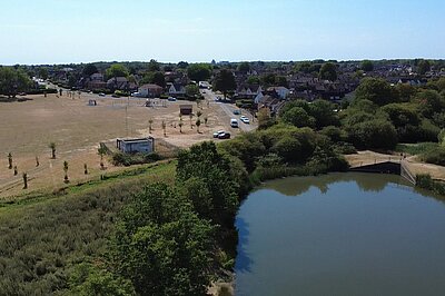
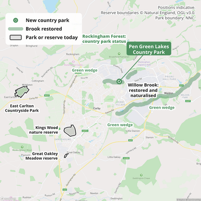
Our headline environmental commitment is the creation of a country park at Pen Green Lakes. The balancing lakes off Pen Green Lane, together with the surrounding grassland and the Willow Brook North corridor, form the largest accessible green space within walking distance of Corby's northern and central estates. It is already used daily by local residents and supports substantial wildlife, but it has no formal protection, and its future is genuinely uncertain.
The case for designation rests on four things, all of which are already established rather than speculative:
- Flood function. The site floods. Network Rail has described the adjacent Pen Green aqueduct as the highest flood risk location on the route, with flood modelling indicating roughly a one-in-two annual probability, and flooding here has previously contributed to a train derailment. Willow Brook North alongside the site is a major drainage route for surface water from large parts of northern Corby. Building on this land would transfer risk onto the railway and onto homes downstream.
- Development pressure is real and recurring. A proposal by Countryside Properties for 272 homes on the fields around the lakes was refused in 2022, following a residents' petition of over two hundred names and objections including a strong one from Network Rail. Refusal of one application is not protection; without designation the site will be applied for again.
- Ownership is in flux. The land is largely owned by Homes England, the government's housing and land agency, with a smaller section in housing association ownership and the waterways owned by Anglian Water. Homes England has been preparing the site for market, meaning it could pass into private ownership with a range of uses considered — including, residents fear, warehousing. Public ownership today is an opportunity that will not necessarily exist tomorrow.
- Corby is under-served for accessible country parks. East Carlton Countryside Park is outside the town and reached by car by most visitors; Pen Green Lakes is within walking distance of some of the most deprived wards in England. The health and access case is strongest precisely where the provision is thinnest.
What we propose:
- Formal designation of Pen Green Lakes as a country park for Corby, in the new North Northamptonshire Local Plan, with a defined boundary covering the lakes, the surrounding grassland, and the Willow Brook North corridor.
- Secure the land in public or community hands before it is sold on the open market. Options include acquisition by NNC, a community land trust, or a long lease — assessed openly and quickly, because the disposal timetable is not within the council's control.
- Use Biodiversity Net Gain to fund stewardship. The site is well suited to being designated for BNG offsetting under NNC's Local Nature Recovery Strategy, which would provide a long-term income stream for management rather than leaving the park to compete annually for revenue funding.
- Protect the flood function explicitly in policy, so that the drainage and attenuation role of the lakes is a material planning consideration in its own right and not weighed away scheme by scheme.
- Modest, appropriate access investment: surfaced circular paths, lighting only where it does not harm wildlife, benches, interpretation boards on the site's industrial and natural history, and a properly designed link to the Pen Green Bridge active travel route in Section 7.2.
- A Friends of Pen Green Lakes group formally constituted and supported, building on the residents who ran the campaign against development, with a standing seat at the Joint Infrastructure Forum whenever the park is discussed.
Indicative cost: £2 to £6 million for acquisition (heavily dependent on how the land is valued and on whether public-to-public transfer is possible), plus £1 to £2 million for access infrastructure and a management endowment. This is among the cheapest major commitments in this plan and among the most immediately visible to residents.
9.2 A new reservoir for Greater Corby
We propose that North Northamptonshire Council and Anglian Water jointly assess the case for a new raw water storage reservoir serving Corby and the surrounding area, and that the Greater Corby Joint Infrastructure Forum press for it to be considered in the next round of water resources planning.
The context is not speculative. Corby sits in the Anglian Water region, which serves around 4.3 million people across the East of England including Northamptonshire, and which is the driest region in the United Kingdom. The East of England had the highest population growth in the country in the decade to the 2021 Census, and Anglian Water expects an additional 911,000 people in its region by 2050. The company's Water Resources Management Plan already concludes that demand cannot be met by efficiency and leakage reduction alone and that new raw water storage is required, and two strategic reservoirs — in Lincolnshire and the Cambridgeshire Fens — are being progressed with government backing as the first major reservoirs in England in a generation. Corby, as one of the fastest-growing towns in the region, has a direct interest in where the next tranche of that capacity goes.
A Greater Corby reservoir would be justified on four grounds:
- Water supply resilience for a town that is planning around 13,500 additional homes by 2041, at a point where water scarcity is already blocking housing consents elsewhere in the East of England.
- Flood attenuation. Storage upstream of the town would reduce peak flows in the Willow Brook system, complementing the Pen Green Lakes proposal above and reducing risk to the railway and to homes.
- Drought and climate resilience for agriculture and for the Rockingham Forest landscape, both of which face increasing summer water stress.
- Amenity and biodiversity. Reservoirs in this region are routinely delivered with country park, watersports, and habitat creation alongside — Rutland Water, half an hour away, is the obvious local precedent for what a well-designed reservoir does for a place economically as well as environmentally.
We are clear about what this is: a proposal for serious assessment, not a costed scheme. Reservoir siting is determined by hydrology, geology, and land availability, not by political preference, and a site may or may not exist within the Greater Corby area. Strategic reservoirs are also promoted by water companies through the Water Resources Management Plan process and the RAPID framework, not by district or parish councils. Our ask is therefore that the case be formally put and properly examined, with the Forum and NNC making the representation, rather than Corby's needs being considered only after decisions are taken elsewhere.
9.3 A rewilding strategy for Greater Corby
Corby has an unusual amount of land that nature has already reclaimed without being asked. The ironstone quarries that built the town were abandoned across the second half of the twentieth century, and where they were not returned to agriculture or built over, they have become some of the richest habitat in the county — the thin, lime-rich soils left behind by quarrying support calcareous grassland, orchids, and butterflies that intensively farmed land cannot. The county's own landscape assessment records that these disturbed post-industrial landscapes are often of significant nature conservation interest. Corby's industrial past is, unexpectedly, an ecological asset.
This section sets out a strategy rather than a list of sites. We are deliberately not naming parcels of private land as rewilding candidates: that would be presumptuous towards landowners, and rewilding done well is voluntary, long-term, and led by whoever holds the land. What we can do is set out the principles we would apply, the categories of opportunity we think are worth investigating, and the existing frameworks that any Corby proposal should plug into rather than duplicate.
Build on what already exists
Corby does not need to invent a nature recovery framework. Several are already operating, and the most useful thing Corby can do is connect itself to them properly:
- North Northamptonshire Council's Local Nature Recovery Strategy, published in March 2025 and the second in England to be completed, identifies Rockingham Forest as one of three priority areas alongside the Nene and Ise valleys, with target species including the hazel dormouse, water vole, curlew, and red-shanked carder bee. It comes with a Local Habitat Map showing potential measures across the Rockingham Forest area.
- Rockingham Forest Vision and the National Lottery-funded Building the Links project have already engaged twenty-two parishes and Friends' groups, of which twelve chose to develop Parish Nature Recovery Plans and six had completed them by the end of the project. There is a published guide, and support available from the Nene Rivers Trust, the Wildlife Trust for Beds, Cambs and Northants, Natural England, and NNC.
- The Chequered Skipper butterfly, extinct in England since 1976, has been successfully reintroduced in Rockingham Forest, and Butterfly Conservation's threatened species work continues across the forest's woodlands for the Dingy Skipper, Grizzled Skipper, Wood White, and adders.
- North Northamptonshire Council has already planted 400 trees within the existing shelter belts on Uppingham Road and Cottingham Road in Corby — evidence that habitat work inside the town boundary is both possible and already happening.
- Priors Hall Park's Gulley shows what post-quarry land can become: a 25-acre County Wildlife Site running through the centre of a major new housing development, with roughly two kilometres of wet grassland, reed beds and hawthorn scrub leading to an eight-acre lake, and great crested newts translocated in under Natural England licence.
Our first ask is therefore modest and achievable: that a Nature Recovery Plan for Corby is commissioned under the existing Rockingham Forest framework, by North Northamptonshire Council, or by a constituted community group with its support, using the published guide and the partner support already on offer. Twelve neighbouring parishes have started this. Corby, the largest settlement in the forest area, should not be the gap in the map.
Principles we would apply
- Connection over isolation. The recognised weakness of Rockingham Forest is fragmentation with thirty-one woodland sites marooned in arable land, leaving populations vulnerable. The value of any Corby site lies mainly in whether it helps link existing habitat, not in its size alone.
- Rewilding is a spectrum, not a binary. Most of what is realistic here is at the lighter end: reduced mowing, natural regeneration on marginal land, scrub allowed to develop, watercourses given room. Large-scale grazing-led rewilding of the kind seen on big private estates is unlikely to be available to a town like Corby, and we should not pretend otherwise.
- Land in public or community ownership first. Council-held amenity grassland, verges, closed landfill, balancing ponds, school grounds and highway shelter belts are where a council can actually act, and where the case does not depend on persuading a private owner.
- Access and nature together. Corby's most deprived wards have the least accessible green space. Rewilding that closes land off would fail a basic test; the aim is richer nature that people can still walk in.
- Nothing that undermines flood function. Where a site is doing drainage work, as the Pen Green lakes are, habitat change must be designed around that role, not in tension with it.
- Voluntary, funded, and long-term. Biodiversity Net Gain receipts, Countryside Stewardship, and the Local Nature Recovery Strategy provide routes to pay for management over decades rather than leaving sites to decline after an initial grant.
Categories of opportunity worth investigating
The following are types of land, not designations of specific sites. Each would need survey, landowner consent, and in most cases a proper feasibility assessment before anything could be proposed:
- Post-quarry land. The gullets, spoil and exposed faces left by ironstone working are Corby's most distinctive habitat resource, and the Gulley at Priors Hall demonstrates the value. Where such land survives undeveloped, its ecological interest should be established before its development potential is assumed.
- The field at Pen Green. The grassland around the balancing lakes, currently in Homes England ownership and refused for housing in 2022, is the most obvious candidate for a deliberate habitat approach within the built-up area. Our primary ask for this land remains country park designation (Section 9.1); rewilding is best understood as a question about how part of that country park might be managed once it is secured — allowing scrub and wet grassland to develop alongside maintained paths — rather than as a separate or competing proposal.
- Watercourse corridors. The Willow Brook through the town, and the Harper's Brook and Eye Brook catchments beyond it, are continuous linear features. River and brook corridors are the cheapest form of habitat connection available anywhere, and they deliver flood benefit at the same time.
- Green wedges between settlements. The land separating Corby from Weldon, Stanion, Little Stanion and Rockingham is already proposed for protection in this plan. Land protected from development still needs a purpose, and nature recovery is a stronger long-term justification for a green wedge than emptiness.
- Amenity grassland and verges. Closely mown grass is the default across much of the town and delivers very little. Changed mowing regimes are the lowest-cost intervention available, though they need to be planned and explained rather than simply announced, since unmown grass reads as neglect unless residents have been brought along.
- Highway shelter belts and roadside land. NNC's existing Uppingham Road and Cottingham Road planting shows this land is available and usable; the same principle could extend along other corridors, including any new road built.
- Development-linked land. Biodiversity Net Gain obligations from the West Corby SUE, Priors Hall, Weldon Park and the logistics estates will require off-site habitat somewhere. Corby should be arguing for that investment to land within the Greater Corby area rather than being traded away elsewhere in the county.
What we would ask for
- A Nature Recovery Plan for Corby, prepared under the existing Rockingham Forest framework with partner support, within the first phase of this plan period.
- A habitat and opportunity audit of land in public ownership within the Greater Corby area, published openly, so that the debate proceeds from evidence rather than assertion.
- A presumption that Biodiversity Net Gain receipts generated by Greater Corby development are spent within the Greater Corby area.
- Corby's inclusion in the next phase of Rockingham Forest partnership work, and a standing invitation to the Wildlife Trust, Butterfly Conservation, the Nene Rivers Trust and Natural England to the Joint Infrastructure Forum when nature recovery is on the agenda.
- Community involvement designed in from the start, including school grounds, Friends' groups, and neighbourhood residents' associations, so that habitat change is something residents have chosen rather than something done to them.
We are clear that this is a strategy in outline, not a programme. Rewilding depends on land ownership, ecological survey, and long-term funding, none of which a party document can settle. What it can do is set the direction, identify where a council could act, and make sure Corby is in the room when decisions about nature recovery in Rockingham Forest are taken.
9.4 Woodlands, watercourses and green space
- Country park status for publicly accessible woodland in Rockingham Forest, worked towards with Forestry England, NNC and willing landowners, and invested in to reach the required standard.
- Willow Brook restoration: daylighting and naturalising sections of the watercourse.
- Tree planting target: 50,000 new trees across the Greater Corby Growth Area by 2035, building on NNC's 275-tree commitment along the new station link cycle route.
- Allotments expansion in the south of the town: at least 200 new plots, with locations identified through neighbourhood engagement.
- Protection of the green wedges between Corby and Weldon, Stanion, Little Stanion and Rockingham, so that the settlements retain separate identities as development continues.
- A Greater Corby tree canopy target for streets and estates, with priority given to the neighbourhoods with the least existing canopy cover.
9.5 What Corby will press for
- Pen Green Lakes Country Park designation, with a formal resolution of North Northamptonshire Council within the first year of the plan period.
- An accountable body for any community acquisition or long lease of the Pen Green Lakes site — NNC or a community land trust — identified before the land is marketed.
- A Friends of Pen Green Lakes group constituted and supported with start-up funding.
- Delivery of the Greater Corby allotments expansion programme.
- Delivery of the tree planting target on public land, and tree planting along the active travel routes in Section 7.2.
- The Greater Corby reservoir case put to NNC, Anglian Water, and Water Resources East through the Joint Infrastructure Forum.
- Green space quality and access reported annually, neighbourhood by neighbourhood, in the Infrastructure Watch report.
- A Nature Recovery Plan for Corby commissioned and adopted under the Rockingham Forest framework.
- A published habitat and opportunity audit of publicly owned land in Greater Corby, with grounds maintenance regimes opened to review.
Follow Corby Lib Dems
We're sharing the plan one part at a time on social media. Follow Corby Liberal Democrats to see each film and tell us what you think.
Facebook · Instagram · Bluesky · Threads · TikTok · LinkedIn · YouTube
Want to talk it through? Call Alex Lock on 07794 221431 or message him on WhatsApp.
Want to get involved or have your say? See how to engage with the plan.
Sign up
for email updates